|
1.1. The Department of Airspace Control (DECEA) is the Organization responsible for standardizing, planning, coordinating and controlling the activities of drafting and distributing aeronautical charts, as well as preparing DECEA’s Unified Publication Schedule and keeping it updated and in line with the operational needs and technical capabilities of SISCEAB, issuing the release guidelines, and supervising the elaboration and compliance activities of the Work Program for the publication of Aeronautical Charts - PROCAR.
|
|
1.2. The Aeronautical Cartography Institute (ICA) is the Organization responsible for preparing, complying with and publicizing PROCAR, as well as making the aeronautical charts in accordance with PROCAR and with the requirements established in a specific Standard, complying with the deadlines foreseen in DECEA’s Unified Publication Schedule and making available at AISWEB the aeronautical charts for the use of aviation in general, listed on page GEN 3.2.2.
|
|
1.3. The aeronautical charts cover the airspace above the Brazilian territory, including territorial and jurisdictional waters. In addition to these limits, they also cover other spaces that have been subject of international air navigation agreements. At AISWEB, appropriate charts may be obtained for flight planning purposes.
In the making of aeronautical charts, under DECEA responsibility the Standards and Recommended Practices, as well as the Procedures contained in the Annex 4 to the Convention on International Civil Aviation and Doc 8168/611, Aircraft Operations (Configurations of holding patterns and instrument approach procedures) are applicable. Differences to these provisions are detailed in subsection GEN 1.7. |
|
2.1. The aeronautical charts included in the AIP are kept up to date by amendments to the AIP. Corrections to aeronautical charts not contained in the AIP are promulgated by AIP Amendments and are listed under GEN 3.2.14.
Information concerning the planning for or issuance of new maps and charts is notified by Aeronautical Information Circular. |
|
2.2. If incorrect information detected on published charts is of operational significance, this must be reported to an AIS unit, which will take the suitable corrective measures, or through FALE CONOSCO SAC-DECEA, available at www.aisweb.decea.mil.br
|
|
Main page:
https://aisweb.decea.mil.br/
Aerodromes and TMA Charts: https://aisweb.decea.mil.br/?i=cartas EnRoute Charts: https://aisweb.decea.mil.br/?i=cartas&p=rotas Visual Charts: https://aisweb.decea.mil.br/?i=cartas&p=visuais |
|
a) Enroute Chart (ENRC)
b) Area Chart (ARC) c) Standard Arrival Chart/Instrument (STAR) d) Instrument Approach Chart (IAC) e) Visual Approach Chart (VAC) f) Standard Instrument Departure Chart (SID) g) ATC Surveillance Minimum Altitude Chart (ATCSMAC) h) Aerodrome Chart (ADC) i) Aerodrome Obstacle Chart - Type A (AOC Type A) j) Precision Approach Terrain Chart (PATC) k) Aircraft Parking / Docking Chart (PDC) l) Aerodrome Ground Movement Chart (AGMC) m) World Aeronautical Chart (WAC) n) Visual Air Navigation Chart (CNAV) o) Visual Corridors Charts (REA, REH, REAST, REUL) p) Aeronautical Pilotage Chart (CAP) |
|
a) Enroute Chart
This chart provides information that facilitates navigation along ATS routes, according to the procedures established by the Air Traffic Service. |
|
b) Area Chart
This chart provides detailed information on the terminal areas that facilitate the transitions between the enroute flight and the approach to an aerodrome; between a missed approach and the enroute flight, and the approach to an aerodrome, through terminal areas with complex structures of ATS routes. |
|
c) Standard Arrival Chart/Instrument
It is intended to provide the aircrew with the information necessary to enable them to comply with the designated standard arrival route instrument from the en/route phase to the approach phase. |
|
d) Instrument Approach Chart
This chart provides information that allows the execution of an instrument approach procedure for one or more runways at an aerodrome, including missed approach procedures and, where relevant, the corresponding holding patterns. |
|
e) Visual Approach Chart
This chart will provide flight crews with information that will enable them to move from the en-route and descent phase to the final approach phase on the planned runway, using visual references. |
|
f) Standard Instrument Departure Chart
This chart provides the necessary information for the execution of an instrument flight between the take-off phase and the en-route phase. It is made available to aerodromes that operate by instruments. |
|
g) ATC Surveillance Minimum Altitude Chart
This chart will provide the flight crew with information that will allow them to monitor and verify the altitudes assigned by a controller using an ATS surveillance system. |
|
h) Aerodrome Chart
This chart will provide flight crews with information that facilitates the movement of aircraft on the ground, from the aircraft's parking position to the runway and from the runway to the aircraft's parking position. |
|
i) Aerodrome Obstacle Chart – Type A
This chart, together with the information published in the AIP, contains information that helps decision making in conditions limiting the operation of the aircraft. |
|
j) Precision Approach Terrain Chart
This chart will provide detailed information on the terrain profile (including natural and artificial objects) within a defined portion of the final approach that will allow assessing the terrain effect on determining the decision height. |
|
k) Aircraft Parking / Docking Chart
This letter provides the necessary information to facilitate the movement of aircraft on the ground, between taxiways and parking positions in the aprons and vice versa. |
|
l) Aerodrome Ground Movement Chart
This supplementary chart shall provide flight crews with detailed information to facilitate the ground movement of aircraft to and from the aircraft stands and the parking/ docking of aircraft. |
|
m) World Aeronautical Chart
This chart provides information that meets the needs of air navigation supported by visual reference. In addition, WAC has information that can be used for preflight planning purposes and also as a basis for making other air navigation charts. |
|
n) Visual Air Navigation Chart
These charts provide pilots with information for visual air navigation at low speed, within short or medium distances and flights at low or medium altitudes, and can be used as a basis for the production of WAC and in carrying out flight plans. If the area of the chart is totally devoid of a cartographic base, an Image Chart (CINAV) will be made, that is, with satellite images, containing only planimetric information, without altimetric information. |
|
o) Visual Corridor Chart
The Special VFR Charts for Aircraft (REA) and the Special VFR Charts for Helicopters (REH) are designed for areas where it is necessary to order the use of airspace for visual flights, as required by the control unit. The Special Route Charts for Aircraft Without Transponder (REAST) are made for areas with ATS surveillance, as required by the control unit. The Special Route Charts for Ultralight Aircraft (REUL) are made for areas destined for the flight of ultralight aircraft, at the request of the interested party or the control unit. |
|
p) Aeronautical Pilotage Chart
The Aeronautical Pilotage Charts (CAP) are intended to meet the needs of visual flight for low-altitude and short-distance air operations, within the scope of the Brazilian Air Force (FAB), which require peculiarities of the representation of visual references in scale. It also serves other small civil aviation activities. An image chart (CIAP) is provided for areas without topographic maps produced by IBGE or by the Army Geographic Service Directorate (DSG). The CIAP consists of a mosaic of satellite images with toponymy information from hydrography and planimetry, in addition to the aeronautical theme applied to the image. |
|
Those chart series marked by an asterisk (*) form part of the AIP.
|
|
|
|
The checklist for WAC, CNAV/CINAV, CAP/CIAP, REA, REAST and REH Charts can be consulted at
https://aisweb.decea.mil.br/?i=cartas&p=visuais. See index chart of WAC and CNAV can be viewed below, in GEN 3.2.6.
|
|
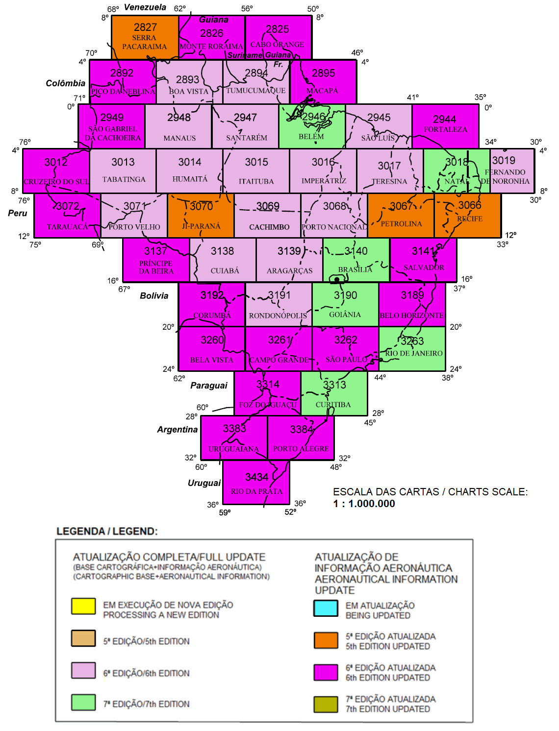
CARTA AERONÁUTICA MUNDIAL / WORLD AERONAUTICAL CHART (WAC)
Atualizado em/Updated on: 22 NOV 25 Também disponível em/Also available at: https://aisweb.decea.mil.br/?i=cartas&p=visuais |
|
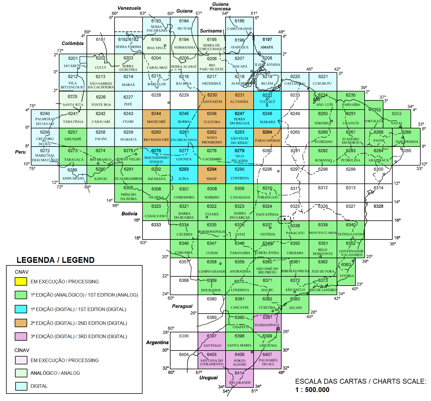
CARTA DE NAVEGAÇÃO AÉREA VISUAL / VISUAL AIR NAVIGATION CHART (CNAV)
CARTA-IMAGEM DE NAVEGAÇÃO AÉREA VISUAL / VISUAL AIR NAVIGATION IMAGE-CHART (CINAV) Atualizado em/Updated on: 22 NOV 25 Também disponível em/Also available at: https://aisweb.decea.mil.br/?i=cartas&p=visuais |
|
Not Applicable.
|
|
The charts followed by an asterisk are included in the AIP.
|
|
|